Whether the grainy pictures that are many many months old will help any terrorist is a moot point.Hey, the only way he/she can use these pictures is to land/crash a plane on the building.Well, most of the planes in India seem to have enough trouble getting off the ground - on time or otherwise and so, to hijack one and crash it in any of these premier installations is in itself a stupendous task.But even if someone does indeed do it......what difference is it goanna make to our country's mothballed bureaucracy? They'll just get a new excuse not to work.
Well, I've gone a lot offtrack.The main point i was attempting to make is that we normal people canmake good use of the Google Earth (which is conveniently free) to show routes inside the city.
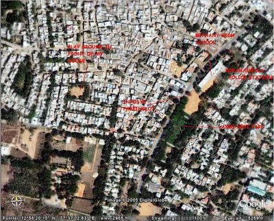
I've made use of it to show the way to my house in the fashionable suburb of Koramangala in Bangalore.The roads may look cool from space...but do not be deceived by the looks, they are treacherously bad!
The first photo is a very high altitude picture which can set the context for the route.I've taken the Hosur Road and FORUM as the main landmarks to my house.

The Second Photo is a lower altitude one which will show the important landmarks in the immediate vicinity of my house.
-Cne -The Coolest Dude

4 comments:
Chennai still seems safe from all these gory details tho!
@ Anonymous Author - What stuff did u post here that u had to remove it urself? I have always been for freedom of expression.As Salman Rushdi says - Freedom of Expression means 'Freedom to Offend'. Please post ur comment.
@ Hari - Maybe because that would open the greatest 'river' in south india - The Cooum to scrutiny!!
cne.. set the mail option in blogger, so that you get the mail once someone posts the comment, so if they even delete their comment a copy would safely reside in mailbox ;-)
-
செந்தில்/Senthil
Post a Comment